Posts Tagged ‘Drone Mapping’
3D Golf Course ,
Cinematography ,
One Drone Cloud ,
PGA Tour 2K21 ,
Press ,
UAV Aerial Cinematography ,
UAV Mapping |
2K Games ,
3D Golf Course ,
3d photogrammetry ,
ar ,
cinematography ,
Drone Mapping ,
Game Development ,
gaming ,
gis ,
golf ,
Golf Course Mapping ,
Golf GPS ,
GPS ,
HB Studios ,
IMU ,
LiDAR ,
MR ,
opengl ,
pga 2k21 ,
PGA Tour ,
Photogrammetry ,
Precision Reality Capture ,
Reality Capture ,
Terra Imaging ,
UAV Mapping ,
vr ,
WebGL Comments Off on PGA Tour 2K21 – “Behind the Scenes Trailer”
3D Golf Course ,
Cinematography ,
One Drone Cloud ,
PGA Tour 2K21 ,
Press |
2K Games ,
3D Golf Course ,
3d photogrammetry ,
ar ,
cinematography ,
Drone Mapping ,
Game Development ,
gaming ,
gis ,
golf ,
Golf Course Mapping ,
Golf GPS ,
GPS ,
HB Studios ,
IMU ,
LiDAR ,
MR ,
opengl ,
pga 2k21 ,
PGA Tour ,
Photogrammetry ,
Precision Reality Capture ,
Reality Capture ,
Terra Imaging ,
UAV Mapping ,
vr ,
WebGL Comments Off on PGA 2K21 – Launching Aug. 21st 2020
3D Golf Course ,
Cinematography ,
One Drone Cloud ,
PGA Tour 2K21 ,
Press ,
UAV Aerial Cinematography ,
UAV Mapping |
2K Games ,
3D Golf Course ,
3d photogrammetry ,
ar ,
cinematography ,
Drone Mapping ,
Game Development ,
gaming ,
gis ,
golf ,
Golf Course Mapping ,
Golf GPS ,
GPS ,
HB Studios ,
IMU ,
LiDAR ,
MR ,
opengl ,
pga 2k21 ,
PGA Tour ,
Photogrammetry ,
Precision Reality Capture ,
Reality Capture ,
Terra Imaging ,
UAV Mapping ,
vr ,
WebGL
Microsoft Hololens Golf – Hololens Golf Simulation and Hololens Sports Broadcast
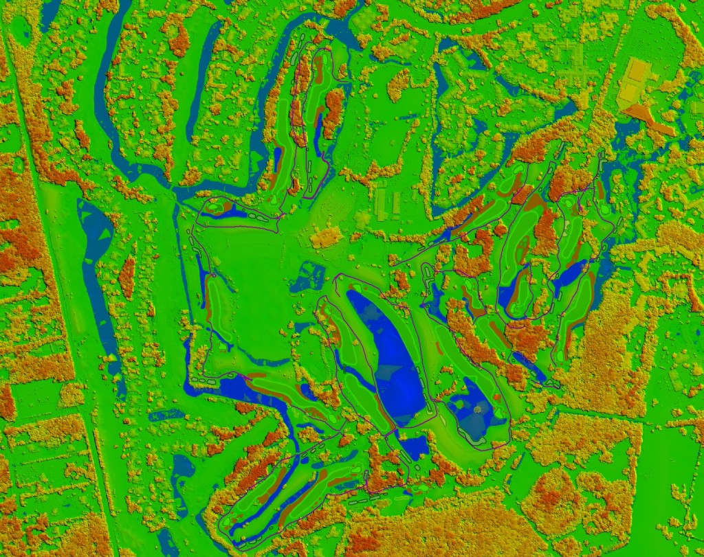
Terra Imaging mapping data (airborne stereo photogrammetry) and our 3D Golf Course software running live in Microsoft Hololens.
US Open 2016 – Oakmont Country Club – USGA
VIDEO
Press |
2K Games ,
3D Golf Course ,
3d photogrammetry ,
ar ,
cinematography ,
Drone Mapping ,
Game Development ,
gaming ,
geospatial ,
gis ,
golf ,
Golf Course Mapping ,
Golf GPS ,
GPS ,
HB Studios ,
hololens golf ,
IMU ,
LiDAR ,
microsoft hololens ,
microsoft hololens golf gaming ,
MR ,
opengl ,
pga 2k21 ,
PGA Tour ,
Photogrammetry ,
Precision Reality Capture ,
Reality Capture ,
Terra Imaging ,
UAV Mapping ,
vr ,
WebGL
VIDEO
Comments Off on PGA 2K21
Torrey Pines “South Course” – Hole 18 – Produced with high resolution Photogrammetry and LiDAR terrain modeling. Geospatial data acquired with Microsoft Ultra Cam and Leica HDS LiDAR sensors…
– 3D Photogrammetry
– 3D Terrestrial LiDAR
3D Golf Course ,
Apple iPhone - iPad ,
Golf Course GPS ,
Torrey Pines ,
UAV Mapping |
Apple ,
Apple iPhone - iPad ,
Bing ,
DEM ,
Drone Mapping ,
Golf Course Mapping ,
LiDAR ,
PGA Tour ,
Torrey Pines ,
UAS Mapping ,
UAV Mapping ,
US Open
Augmented Reality iPhone Application – High Resolution Photogrammetry, LiDAR and GPS Data.
3D Golf Course ,
Apple iPhone - iPad ,
UAV Mapping |
Apple iPad ,
Apple iPhone - iPad ,
Drone Mapping ,
LiDAR ,
Microsoft Bing ,
PGA Tour ,
UAS ,
UAV ,
US Open ,
USGA Comments Off on Augmented Reality iPhone Golf GPS
Torrey Pines South Course – Hole 3 – Produced with high resolution Photogrammetry and LiDAR terrain modeling. Geospatial data acquired with Microsoft Ultra Cam and Leica HDS LiDAR sensors.
3D Golf Course ,
Apple iPhone - iPad ,
Golf Course GPS ,
Torrey Pines ,
UAV Mapping |
Apple iPad ,
Apple iPhone - iPad ,
Drone Mapping ,
Golf Course Mapping ,
LiDAR ,
PGA Tour ,
Torrey Pines ,
UAS ,
UAV ,
US Open ,
USGA